

When you’ve been counting for almost a century, you know you’re doing something right.
About Acadia National Park
Acadia National Park is one of the most popular national parks in the United States and the only one in Maine. This 47,000-acre collection of trails, mountains, and coastlines is open year-round to domestic and international visitors.
The park’s origins are unique: it was the first national park to have begun through private land donations. Adding to this, it has a rich history of counting. Almost a century ago, Acadia’s first counting program in the 1930s-40s had volunteers counting cars as they entered the park. In the 1970s, they started to count more extensively by manually counting pedestrians, and then in the early 2000’s, they put up their first automated trail counter.
The Challenges Acadia National Park Faces

Long Pond and the western mountains of Mount Desert Island in Acadia National Park. (Photo by Will Greene / Friends of Acadia / NPS)
The challenges and difficulties Acadia faces are like those of any national park across North America. Despite its high visitation (4 million estimated visits per year), Acadia is one of the smallest national parks in the United States – placing 50th out of 63 by size. This makes managing visitation numbers and allocating resources a key concern. Adding to this challenge are its abundance of precious flora and fauna, hiking trails, and restricted areas that change seasonally.
Naturally, Acadia’s park managers have many questions. How many people enter the park at a given time? Where are they going? What can they do with this information to ensure the park remains safe and healthy for the next generations?
How Acadia National Park Uses Counting for Park Improvement
How do you keep track of visitation on 27 miles of motor roads, 158 miles of hiking trails, and 45 miles of carriage roads at once?
The answer is creativity, planning, and a lot of help.
The incredible teams at Acadia National Park and the Friends of Acadia work tirelessly to ensure the park runs smoothly every day. One cornerstone of their work is using automated counters to help gather continuous data in strategic places at strategic times.
This data informs managerial decisions and measures the success of their past initiatives. As you might imagine, they’ve done this many times in their decades of counting. However, here are five innovative examples of how they use their count data to improve their park.
Example 1: Vehicle Reservations on Cadillac Mountain

A sunrise atop Cadillac Mountain in Acadia National Park. (Photo by Sam Mallon/Friends of Acadia)
Cadillac Mountain is the highest peak in Acadia National Park and the highest point on the Eastern seaboard of the U.S. With an elevation of 1530 feet, it’s extremely popular amongst visitors who love beautiful sunsets and gratifying hikes.
In recent years, Acadia introduced a timeslot-based vehicle reservation system to help manage vehicles on the mountain. Without purchasing a reservation, visitors can’t take their cars up to the summit via Cadillac Summit Road.
That said, there was a caveat. Visitors who accessed the mountain by foot or bike did not require a reservation. This meant they could visit for free so long as they had their Acadia National Park pass!
Of course, management did this on purpose. To protect the longevity of the mountain, Acadia wanted to push people towards more sustainable modes of transport. On top of this, they also aimed to improve safety. Acadia’s team saw that, due to the high vehicle density, emergency vehicles could not come up the mountain at certain times of day.

Heavy traffic congestion on Park Loop Road near Sand Beach in Acadia National Park. (Photo by Sam Mallon/Friends of Acadia)
Consequently, a win-win situation was created. Namely, visitors could save money, and the park could reduce their vehicle traffic and emissions, as well as improve the safety of their mountain.
But how would they know if their idea worked? The answer was placing trail counters at key points on the trail up to the summit. Notably, these points were only accessible by cyclists and pedestrians.
Acadia knew more people would choose to hike. However, the counters were pivotal for them to understand exactly how many more people walked their trails. Was it a 10% increase, or did trail-goers double? With automated counters, Acadia could get solid numbers instead of general observations.
From there, they could assign staff to monitor and direct the traffic flow of people on the trails. Additionally, they could schedule more frequent maintenance in high-traffic areas and crossings.
Example 2: Preserving Vegetation on Sargent Mountain and Penobscot Mountain

A climate adaptation scientist at the Schoodic Institute drops off a bag of soil at the summit of Sargent Mountain during the Save our Summits hike. (Photo by Sam Mallon/Friends of Acadia)
Sargent Mountain is Acadia National Park’s second-highest peak, at 1370 feet (417m). Penobscot mountain is close behind at fifth, with a peak of 974 feet (297m). Hikers who reach the top of these two mountains receive stunning 360-degree views and a chance to dip in Maine’s oldest lake, Sargent Mountain Pond.
However, as with many popular mountainous attractions, Sargent Mountain and Penobscot Mountain suffer from a serious problem: vegetation degradation.
Usually, the greenery that grows on mountains – shrubs, wildflowers, and lichens – are survival experts. But years of climate change and trampling by increased visitors have strained the ecosystem on each mountain’s summit. What’s more, fencing off the areas that needed to be regrown wasn’t enough. The root of the problem was the soil itself.
So, in June 2023, 72 volunteers carried bag upon bag of topsoil up Sargent Mountain and Penobscot Mountain to reinvigorate the growth of flora. They focused on building restoration plots on heavily worn “social trails” – unofficial footpaths created by hikers.
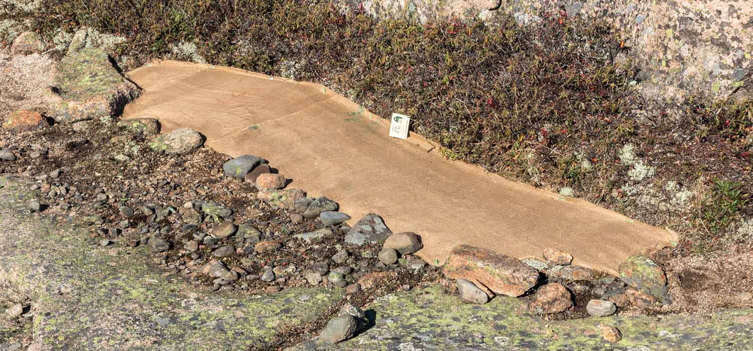
Scientists from Schoodic Institute and Acadia National Park apply soil to plots on Penobscot Mountain. (Photo by Edward Muennich/Friends of Acadia)
But the job wasn’t done.
How could they make sure the restoration plots stayed undisturbed? In a research study with the University of Maine, the Friends of Acadia used trail counters, surveys, and trail cameras to answer several pressing questions.
For one, they wanted to understand the pure volume of visitors to the areas. Also, they wanted to know how quickly the numbers were increasing each year. Trail counts were essential to this, as they helped them get a general idea of how often plots needed to be checked on.
Then, they wanted to see if people were going to the places where the plots were. For this, trail counters and cameras came in handy. Once they saw visits, they could send helpers to rejuvenate the plots.

A sign next to a pile of soil educates visitors along the carriage roads during the Soil on Summits hike up Sargent and Penobscot Mountains in Acadia National Park. (Photo by Sam Mallon/Friends of Acadia)
Finally, they wanted to see if their QR codes were working. To educate passersby about their restoration initiative, they put up QR codes on educational signs in the areas. By comparing QR code numbers with visitor counts, they could get an idea of the percentage of people who engaged with their signage.
Example 3: Nesting Season on Champlain Mountain

A peregrine falcon flying as seen from the Jordan Cliffs in Acadia National Park. (Photo: Emma Forthofer/Friends of Acadia)
Have you ever heard of the Peregrine Falcon? Peregrine falcons are a protected species, and Acadia National Park provides a habitat for this amazing bird of prey. In the summer months, usually around April to August, these birds have their nesting season.
During this time, people must stay off the trails close to where these birds raise their young.
Therefore, Acadia shuts down areas of the park during this time, one of them being Champlain Mountain. The benefit of this is twofold. For one, the birds and their young are protected from outside stressors caused by crowds of people. Secondly, the people are protected from the birds! During nesting season, Peregrine Falcons become more aggressive and territorial, and a surprise attack could ruin the fun atmosphere for unsuspecting hikers.

Peregrine falcons perch near their nest on the Jordan Cliffs in Acadia National Park. (Photo by Ashley L. Conti/Friends of Acadia)
In observance of these initiatives, Acadia installs trail counters on Champlain Mountain to see counts of people who stumble into restricted areas. If the numbers get too high, they can have staff intervene and redirect traffic.
Similarly, the trail counts give management an idea of the effectiveness of their signage. Are people paying attention to signs that restrict entry? Or are they going in anyway? With counters installed, Acadia can judge where signage is working and where they need to put up larger or more informative signs. Then, if counts are still too high, they can take further steps by blocking off the trail or the parking lot (which they had to do this year!).
Example 4: Safety on the Precipice Trail
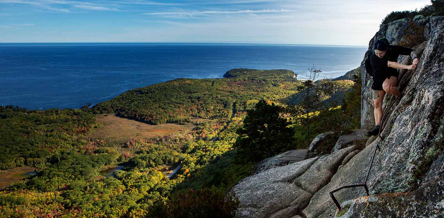
A hiker uses iron rungs to climb up the Precipice Trail in Acadia National Park. (Photo by Ashley L. Conti/Friends of Acadia)
But the story doesn’t end there! Once the floodgates finally open around August and the falcon younglings leave the nest, Champlain Mountain experiences a massive influx of hikers.
But, for one trail on Champlain Mountain, having too many visitors becomes an important issue of safety.
The Precipice Trail rises over 1,000 feet in less than a mile, featuring metal rungs, ladders, stone staircases, and open cliff faces. Its allure is bolstered by its narrow window of availability from late summer to early winter.

An Acadia National Park Intern climbs up the Precipice Trail going up Champlain Mountain during off time in Acadia National Park. (Photo by Sam Mallon/Friends of Acadia)
On busy summer weekends, the trail could see over 1200 people a day. Knowing this, managers at Acadia placed counters along the trail.
These counters measure visitation to give Acadia an idea of which days and times were the busiest. Then, they used this data as a predictive tool to send park rangers to conduct preventative search and rescue at key locations. The data would also show them which areas were the most crowded on the day of. As a result, park rangers would know where to redirect people to prevent dangerous crowds on Precipice’s narrow footpaths.
Moreover, the direction detection function of these counters helped identify if hikers were descending the trail. Descending the trail meant going against the flow of traffic, which is extremely dangerous. Thus, areas with high “out” counts (as opposed to “in”) were stationed with rangers and signage to remind people not to come back down against traffic.
Example 5: Improving Visitor Experience on Carriage Roads
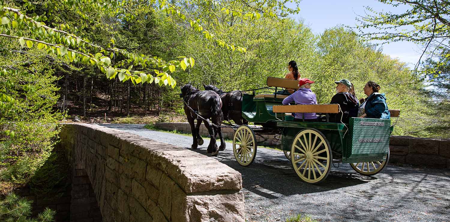
Wheelchair Accessible Carriage funded by the Diana Davis Spencer Foundation crosses over the Stanley Brook carriage road bridge in Seal Harbor. (Photo by Julia Walker Thomas/Friends of Acadia)
Acadia National Park’s carriage roads are one of its most unique features. Built close to a century ago, they were a gift from John D. Rockefeller Jr. to travel by horseback to Mount Desert Island without the interference of motor vehicles.
Today, these roads continue to benefit park visitors tenfold. Stretching over 45 miles (72 km) and blending seamlessly with the landscape, they beautifully showcase Acadia’s mountains, valleys, and waterfalls. However, they can become crowded during peak seasons, prompting park management to use trail counters.
By counting at critical points on the carriage roads, Acadia can better understand their carrying capacities. In essence, a road’s carrying capacity is the number of people that can be on it before it becomes “too crowded.”
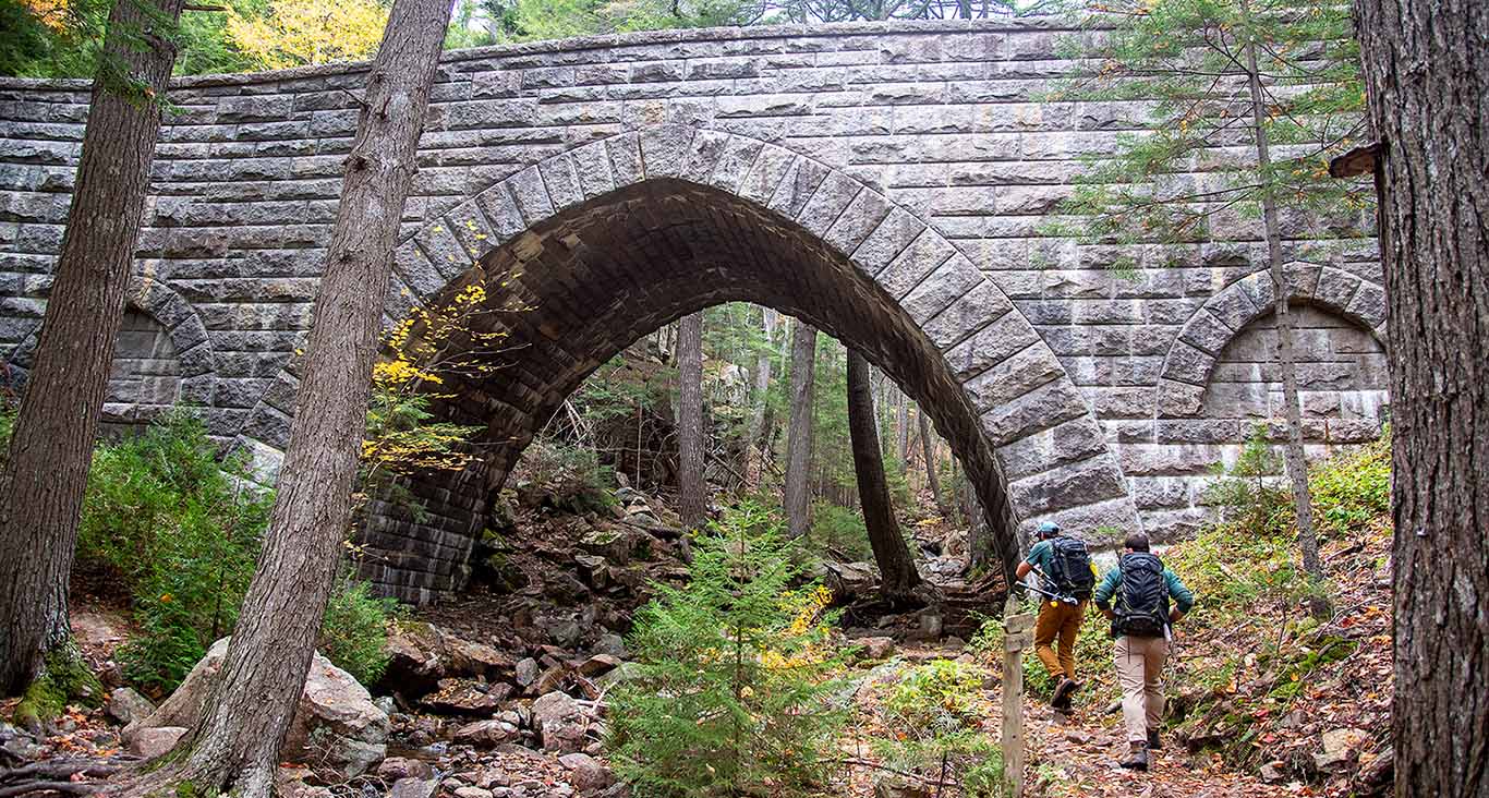
Friends of Acadia Summit Stewards hike the Maple Spring trail in Acadia National Park. (Photo by Will Newton/Friends of Acadia)
With this information and their counters’ ability to track bike and pedestrian counts per hour, Acadia considerably improved their crowd management.
For example, they mobilized park staff to recommend alternate routes when a road got too busy to give pedestrians a better, quieter, more solitary experience. Since they had data for both bicycles and pedestrians, they did the same with cyclists as they checked in to the visitor center.
Similarly, they adapted their carriage tour routes when certain areas became too populated to give customers a smoother, less crowded ride.
Conclusion
In summary, Acadia National Park is an excellent example of how a national park can implement counting at a high level. Amazingly, this is only the beginning for them. All the examples included in this article were from recent years.
Parks can benefit from trail counters in various unique and impactful ways. We’re proud to provide counters, data software, and other products to numerous parks across North America, including Acadia National Park.
If you’re interested in starting or improving a count program at your park, read more about our solutions below, including the counters Acadia used:


There is no comments